By early June, a report is due to Cincinnati City Council on the feasibility of a "road diet" redesign of .
At its May 9 meeting, councilmembers Chris Seelbach, Yvette Simpson, Wendell Young and Vice Mayor Roxanne Qualls introduced a motion asking the City's Department of Transportation and Engineering to look into changes to the heavily-trafficked corridor that could restore its pedestrian character and make it more attractive for mixed-use, sustainable redevelopment.
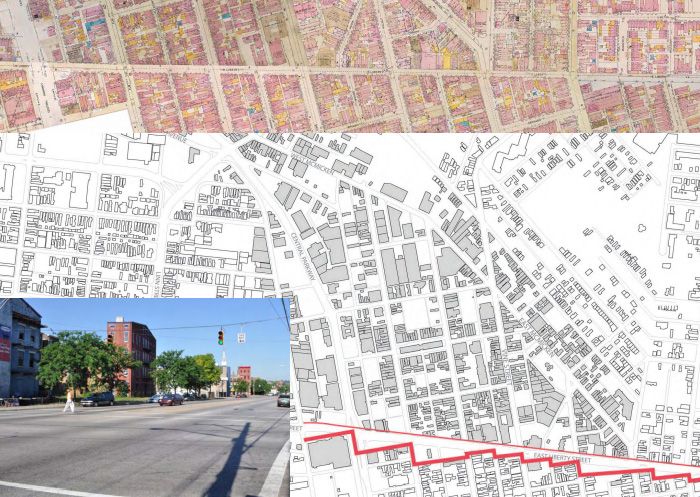
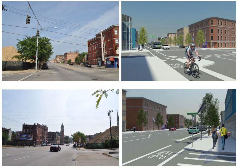
In 1957, Liberty Street was widened to facilitate the rapid east-west movement of automobile traffic. To accomplish this task, dozens of buildings along the south side of the street were demolished, removing the street's once-dense and thriving urban fabric and effectively dividing the Over-the-Rhine neighborhood in two.
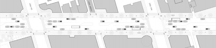
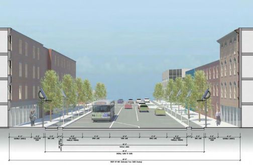
To correct this problem, the 2011 Brewery District Master Plan proposed "complete streets" refinements to the roadway, such as lane reductions, bump outs, streetscaping, intersection redesign and retiming, widened sidewalks and bike lanes.
The new Liberty Street would accommodate five lanes for motor vehicles, two lanes for bicycles, and widened sidewalks. The outermost vehicle lanes would be used for parallel parking, and the center lane would be used for left turns.
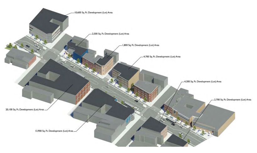
Additionally, the master plan suggests that there are more than four acres of vacant or undeveloped land along the street. These parcels represent an opportunity to recreate streetscapes that address both Liberty Street and its intersecting north-south secondary streets.
Qualls has been the City's foremost proponent of local Complete Streets standards, first introducing the idea in a Council motion in August 2009.
Since then, complete streets, road diet concepts have been studied for Montana Avenue in Westwood, Madison Road in O'Bryonville/Hyde Park, Beechmont Avenue in Mount Washington, and William H Taft Road and E McMillan Street in Walnut Hills.
New City-wide street standards are expected to be finalized later this summer and will be added to the City's new form-based code and Plan Cincinnati comprehensive master plan.
Images courtesy of the 2011 Brewery District Master Plan.
Previous reading on BC:
Conversion of Taft and E McMillan should wait, report says (8/9/10)
Cincinnati seeking input on Madison Road 'complete streets' project (6/30/10)
Sixteen properties to be affected by Montana Avenue project (4/21/10)
Transit-oriented zoning to be before Cincinnati council by September (4/5/10)
Qualls motion asks for Complete Streets strategy (8/10/09)
Monday, May 14, 2012
Subscribe to: Post Comments (Atom)
15 comments:
I am glad to see in the design that there is a median between the cars and bikes. I don't know how many times I see cars wander into the bike lane which is not a big deal if there are no bikes, but a bad habit and a possible danger in the future. Hopefully the median will also mean that drivers will stop treating bicyclists so poorly by swerving around and almost hitting them.
This would be beyond fantastic to see happen. Liberty Street is currently a dead zone in Over-the-Rhine, and it is woefully over-sized. Take out some of those traffic lanes and rebuilt the urban fabric that once existed.
Thanks for reporting on this, Kevin.
I love this idea! I've always thought widening Liberty was one of the worst decisions for Over-the-Rhine the city has ever made. Completely separated the neighborhood in half.
You cannot take away the traffic lanes! When the casino opens the traffic coming from 75 over liberty to Reading will be heavy and it is already a major trucking corridor for 71/75 access. Bike lanes are a great idea so getting rid of the parking is the only option for improvement here. IMO!
The reason the Liberty Street right-of-way is so wide is that in the early- to mid-Fifties serious consideration was given to making LIberty Street the path for I-71 to tie into I-75.
Eventually, downtown interests who wanted to seal-off the then-dilapidated central riverfront won the argument and caused I-71 to be built along what is now Fort Washington Way.
Progressive thinkers of the day (there were some) warned that building a 750 foot-wide freeway along the rivefront would condemn it to mediocrity forever. And it did -- for over forty years until the FWW trench was shrunk to 375 feet in 1998-2000 and the street grid restored over it.
There's a lot of history here.
Good for Roxanne Qualls for finally starting the process of correcting this mistake.
Trucking corridor for I-75? Maybe Central Parkway. The quickest way to go from I-75 to I-71 is FWW, not Liberty.
Great idea, long overdue. Can Linn Street be next?
I agree with Linn Street too. That needs to be calmed down
@ Schneider-
Correction, Councilmember Seelbach drafted the motion which was then signed by Qualls, Simpson & Young.
Anonymous 2:49 PM: I love the idea too, and I believe that's where meters and signs will be placed too, meaning that a passenger can't open the car door and hit a cyclist.
Randy: How could I not report on this? :) This is something that's bothered me ever since I've cared about the City!
Brian: I think I-71, Gilbert, and Reading will bear the brunt of the casino traffic, and I would hope that drivers would be encouraged to swing through Ft. Washington Way and come around rather than get bogged down by all of the ill-timed traffic lights on Liberty (like Justin said. Also, your concerns about on-street parking can be alleviated by making on-street parking illegal during peak hours.
John Schneider: Thanks for your insight, as always.
To reiterate...the motion came out of Chris Seelbach's office. Qualls, Simpson and Young were supporters and signatories.
John, this predates my personal narrative a bit, but my understanding of history is that it was the 'progressive' thinkers that tore down or tried to tear down our cities and make them parks and raceways. Today's progressive ideas, held 60 years ago, would place you squarely in opposition to that era's progress.
Quite open to a new understanding, wondering if you could comment on that.
First, apologies to Chris Seelbach for not crediting him with this proposal.
On the progressive Cincinnati thinkers of the Fifties, there was a group that called itself the "The Determined Young Men" and, among other things, they were very concerned that building an Interstate Highway along the riverfront would forever sever it from the rest of the CBD and make it pretty much useless. I've heard Neil Bortz had a foot in this camp. Something I want to ask him someday.
This happened in many American cities. President Eisenhowwe envisioned freeways' stopping at the urban edge and traffic using arterials and boulevards to enter the city -- sort of like the German model he saw leading the 1944-1945 liberation of Europe. But the big-city mayors had other ideas. They wanted "slum clearance," and so they used the IHS to clear-out or seal-off large sections of cities. They captured the program, and now we have the cities we have. Or what's left of thsm.
Love the idea too. Do it.
The question of casino traffic is sticking with me though... I don't know how many casino patrons will be arriving via I-75, but what would be the preferred route? FWW to I-71's Eden Park/Reading Road Exit then doubling back on Gilbert or Reading? Seems a little convoluted.
^ That I don't know either. I guess you can't control how people arrive at your doorstep...hell, I take the craziest routes to about everywhere I go.
I just get the feeling that there will be a push for signage that directs people along FWW and up I-71. Hell, my ex lived in Mt. Auburn, and it was faster to go that way than via Liberty.
Post a Comment